Right Social Links

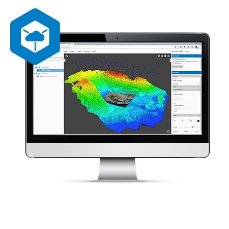
A 3D software environment to combine data sets from multiple mass data sensors
MAGNET Collage provides data processing of otherwise disparate data sets into one 3D environment that can accommodate laser scanner, mobile scanning and mapping, road resurfacing scanners, and photogrammetric point clouds. To further simplify the combination of data, geographic coordinate points from ground control and surveying control can be leveraged for easy matching of point clouds.
- Combine Mobile and Static scan data into one immersive 3D environment.
- Faster point cloud processing and mass data handling
- Combine Civil, Mapping, BIM, and survey data
- Advanced matching and ground control functionality for a variety of sensors
- Extensive projections and geoids exports
- Segment and reduce point clouds to facilitate import into third-party software
- All in one mass data processing software
MS Series SpecificationsPrint
Angle Measurement
Accuracy MS05AXII: 0.5” MS1AXII: 1”
Minimum Reading MS05AX: 0.1″ MS1AX: 0.5″
*ISO 17123-3
Distance Measurement
Reflectorless MS05AX: 0.5 to 100m MS1AX: 0.5 to 400m
Reflective Sheet 1.3 to 200m for both
Prism 1.3 to 3,500m for both
Accuracy
Reflectorless MS05AX: (1 + 1ppm X D)mm MS1AX: (2 + 1ppm X D) mm
Reflective SheetMS05AX: (0.5 + 1ppm X D)mm MS1AX: (1 + 1ppm X D)mm
Prism MS05AX: (0.8 + 1ppm X D)mm MS1AX: (1 + 1ppm X D)mm
Minimum Reading MS05AX: 0.01mm / 0.1mm MS1AX: 0.1mm / 1mm
Physical and Environmental
Ingress Protection IP-64
Operating Temperature -10 to +50 ºC
Storage Temperature -30 to +70 ºC
 Dealer Network